Who We Are

Rural Maps is an award winning cartography studio specializing in creating exceptional maps for private landowners worldwide.
Anthony Pelly, a 6th-generation farmer, leads Rural Maps while managing his family farm in Hampshire. With a degrees in design and architecture from colleges in the USA and UK, Anthony founded Rural Maps in 2013. He divides his time between Wyoming, Hampshire, and Corfu, Greece. His background in farming, ranching, and rural project management has deepened his understanding of the critical role a well-crafted map plays in efficient project management. Anthony also sits on The Rural Business Group, meeting with the Prime Minister’s team at 10 Downing Street to discuss both contemporary and traditional rural business initiatives.
Catherine works closely with clients to capture the unique requirements of each map commission. She liaises with data providers and processes information as it comes back from the client. Together with Anthony, Catherine explores innovative ways that mapping can enhance the management of rural landscapes across various contexts and countries.
Rachel splits her time between her London studio and the Rural Maps base in Hampshire. With a strong background in architecture and design, she employs CAD software and her artistic skills to create maps that are both functional and aesthetically pleasing. Frequently found in the map room at the British Library, Rachel draws on her deep knowledge of cartographic history and art to refine her mapping techniques.
Jonathan lives in West Wales, “somewhere by the river” surrounded by high wooded hills, ruined castles and wild moorland. Inspired by Victorian art, his work has a traditional feel, combining realism and a strong sense of narrative. His approach is highly individual with all the elements within - subject, flora and landscape - being treated with equal importance. His work is therefore, part portrait, part botanical and part landscape, an approach that places the subject within the context of habitat, time and place and gives added opportunity for narrative within the map.
Our Studio
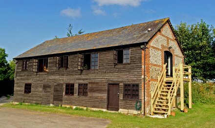

The team at Rural Maps operates from a beautifully converted brick and flint barn nestled high on the South Downs, amidst a working farm.
As a small, dedicated team, they collaborate closely with a diverse network of graphic designers, map data specialists, illustrators, fine art printers, and framers to produce comprehensive maps for landowners worldwide.
The bespoke nature of their work fosters a close relationship with clients throughout the entire process, ensuring their input is integral to the evolving design of each map.
To date, the studio has mapped in excess of 2,000,000 acres around the world.